Hostilities recommenced in India between the French and the English in AD.1758 on the outbreak of Seven Years War in Europe in A.D.1756. As a result, the French lost their power in India and consequently it also lost influence at Hyderabad. In A.D.1762 Nizam Ali Khan dislodged Salabat Jung and proclaimed himself as Nizam.
Hyderabad came into focus again when Nizam Ali Khan (Nizam II) in A.D.1763 shifted the capital of the Deccan from Aurangabad to Hyderabad. Such a move helped rapid economic growth and expansion of the city, resulting in its importance and prosperity.
Between A.D.1766 and A.D.1800, Nizam's sovereignty had declined considerably and the British gained their authority over the Nizams by compelling the latter to sign six treaties.
In A.D.1766, the Nizam signed a treaty with the British, whereby in return for the Northern Circars, the British agreed to furnish Nizam Ali Khan with a subsidiary force as and when required and to pay Rs.9 lakhs per annum when the assistance of the troops was not required in lieu of Northern Circars to be ceded to them. In A.D.1768 he signed another treaty conferring the Northern Circars to the British and the payment by the British was reduced to Rs.7 lakhs. According to another treaty, he surrendered the Guntur circar in A.D.1788. In A.D.1779, the Nizam conspired with Hyder Ali of Mysore and the Peshwa of the Marathas to drive away the English. When they learnt about his designs, the English marched against the Nizam who had to sue for peace agreeing to the presence of an English Resident along with army, artillery and cavalry at Hyderabad
Showing posts with label satavahana kings. Show all posts
Showing posts with label satavahana kings. Show all posts
Wednesday, April 7, 2010
Wednesday, March 31, 2010
Centre's decision to form Telangana
Deccan Chronicle
The largest selling English daily in Bangalore and Hyderabad
Your Ad Here
Friday, December 11, 2009
Decision on Telangana driven by Rahul's plan to split UP
Several Congress leaders feel that the Centre's decision to form Telangana is part of a longterm strategy chalked out by the AICC general secretary, Mr Rahul Gandhi, who wants to gain hold over Uttar Pradesh by dividing it into Bundelkhand and Purvanchal.
The Centre's decision on Telangana would bring life to agitations in the two regions of UP and would aid Mr Gandhi's political strategies.
Tuesday, March 30, 2010
SARKAR SEEMA under Presidency RULE

The Madras presidency was administered by a governor and a council, consisting of two members of the civil service, which number may be increased to four. There was also a board of revenue of three members. For legislative purposes the council of the governor was augmented by additional members, numbering 45 in all, of whom not more than 17 may be nominated officials, while 19 were elected by various representative constituencies. Members of the legislative council enjoyed the right of interpolation, of proposing resolutions on matters of public interest, and of discussing the annual financial statement.
In 1911 the province was divided into 24 districts: Ganjam, Vizagapatam (Visakhapatnam), Godavari, Krishna, Kurnool, Nellore, Cuddapah, Anantapur, Bellary, North Arcot, South Arcot, Chingleput, Madras, Salem, South Canara, Malabar, Coimbatore, Tiruchirappalli, Tanjore, Madurai, Tirunelveli, The Nilgiris, and Guntur. Each district was under the charge of a collector, with sub-collectors and assistants. The districts were not grouped into divisions or commissionerships, as in other provinces
Monday, March 29, 2010
TCMG goes to New delhi on Telangana
Telangana tale is full of
continuous oppression,
imperialism,
colonization,
expansionism,
linguistic abuse
and
human rights violations.
At present, TELANGANA is in UNPRECEDENTED MASS UPHEAVAL.
The word TELANGANA is thousands of years old. It means the land where Telugu is
spoken. The land has civilization of thousands of years.
Monday, March 8, 2010
SATAVAHANA COINS
Satavahana rulers were subdued during the period of Asoka but were independent
rulers from 8 th c BC,as given the privilege to be of vishvamitra lineage, In puranas
they were referred as satavahanas,satakarni,and Andhras, they have 30 forts ,
1000 elephants,100,000 infantry,2000cavalry.
The Deccan region was covered by large number of small tribal
kings which were often in war among themselves.
The Satavahana were the strongest among them after naga kings,
In this way the kingdom of satavahana came into existence in telanagana
region defeating the mahatalavaras.We get numismatic evidence to prove
this point enclosing the photo of rare Mahatalavarasa coin from my coin
collection along With some satavahana coins too from various coin collectors
collection which were worth noting in explaining the expertise used in minting
and various designs from various regional mints of one king and
Of other satavahana rulers Explained,
MAHATALAVARASA TELUGU WORDS OF PRE STAVAHANA KINGS
The history of Satavahana dynasty start from Karimanagar,Adilabad region.
Before them the MahatalavarasRuled this region, we come across coins of
Mahatalavara and other pre –Satavahana rulers, But lack of
Script on coins make us puzzled about their history. But their
style of design on coins gives us their Independent style of coin minting than
north India, gives us clue about their existence before satavahana
dynasty. Recent discovery of fort at near water falls in Ichoda mandal
gives us proof about that.The cobbled
pathwayfortifications show us the importance of this fort ,at we may
assume it was the capital of satavahana dynasty The pottery with
several circles gives us it is of new type as similar seals are excavated in Egypt
also, which show us the satavahana maritime trade. Early period of satavahana
trade flourished with Egypt
sumeria,hittitites,which made south India the hub of trade,we exported spices
and got in exchange gold. Diamond mines were famous in whole world,
Queens were given important place in satavahana dynasty
Queen Naganika,wife of satakarni was perhaps the first queen found on
incriptions.,Even Nanaghat,Nasik incriptions give details of satavahana
rulers.Satavahana kings were first to issue the silver coins with portrait of king face.
They equally gave donations to Buddhist,Jain,Brahmains.
Conducted Ashwamedha yagnamto show their strength. They ruled whole of
telangana,Andhra,Karnataka,konkan,maharshatra,vidraba,gone
upto Gujarat,Vidisha in north and still further. South Indian history was
given little importance sofar, specially satavahana period for lack of
encouragement and was neglected. We were first to trade with outside world,
build ocean going ships and mint it on coins.
HISTORY OF SATAVAHANA FEMALE ATTENDEANTS

atavahana rulers were quoted in old works like the Aitareya Brahmana,the Epics ,
the Paraná’s, the early Buddhist and Jain works.Gunadhya’s Brhatkatha,
Hala’s Gathasaptasati and Vatsyayana’sKamasutras reflected the
social and cultural life of the Satavahana period.
The Kathasaritsagara mentions the story of a king named Dipakarni
who saw a boy riding a Sata or lion, adopted him and named him
Satavahana
‘Satavahana’ and ‘Satakarni’ are the two standard names by which the
rulers of that dynasty are referred to in their inscriptions and coins.
Various explanations have been given for these names: Satkarni means
” the son of a horse”, and explained in terms of the Aswamedha tradition.
Barnett explained Satkarni as meaning the son of Sata. Sometime it is taken
to mean as one who has a hundred ships, or one whose vehicle is drawn by
hundred bulls or the one with his ears bored. The Kathasaritsagara mentions
the story of a king named Dipakarni who saw a boy riding a Sata or lion,
adopted him and named him Satavahana or the one who had a lion for his vehicle.
It is also suggested that Satavahana is only a variant of ‘Saptavahana’,
meaning the sun, and that they were so called because they were the worshippers
of the sun. these theories, however, have been discarded by Dr. M. Rama Rao,
who has argued that the dynasty has been named after the founder of the dynasty,
who ruled before Simukha.
Przyluski thinks that Sata and vahana, the constituents of Satavahana, are both
Mundawords; the former is the Sanskrtisation of the Munda word sadam meaning
a horse and the latter ofhapan meaning a son. Satavahanas were “sons of horse”
as they believed themselves to be born of the chief queen with the sacrificial horse
in the Asvamedha sacrifice So many kings in the Puranic dynasties as well as in
historic ruling families werecelebrated performers of the Asvamedha sacrifice
Even Megashtanes,Pliny ,Ptolemy,wrote refers about
satavahana army ,forts,maritimeTrade,viharas,even Fahein of 5th c AD ,wrote
about the donations to famous viharas by satavahana queens
other version of KOHINOOR

The origin of the diamond is unclear, although rumors abound. According to some sources, the Koh-i-noor was originally found more than 5000 years ago, and is mentioned in ancient Sanskrit writings under the name Syamantaka.[original research?] According to some Hindu mythological accounts, Krishna obtained the diamond from Jambavantha, whose daughter Jambavati later married Krishna. The legend says that the diamond was from the Sun God to Satrajith (father of Satyabhama) which produces 1000 kg of gold daily. Krishna got the blame of stealing the diamond from Satrajith's brother who is killed by a lion which in turn was killed by Jambavantha. Satrajith had alleged that "Krishna probably killed my brother, who went to the forest wearing the jewel on his neck." Krishna, to restore his reputation, fought a fierce battle with Jambavan and gave the stone back to Satrajith. Now being ashamed with himself Satrajith offered his daughter's hand to Krishna along with the stone. Krishna accepted his daughter Satyabhama's hand but refused to take the Syamantaka.
Historical evidence suggests that the Kohinoor originated in the Guntur region of Kakatiya kingdom, in the Indian state of Andhra Pradesh, one of the world's earliest diamond producing regions. This region was the only known source for diamonds until 1730 when diamonds were discovered in Brazil. The term "Golconda" diamond has come to define diamonds of the finest white color, clarity and transparency. They are very rare and highly sought after.
The diamond was mined in the Kollur mines near the village Paritala in the present day Guntur district of Andhra Pradesh.The diamond became the property of Kakatiya kings. The Khilji dynasty at Delhi ended in 1320 A.D. and Ghiyas ud din Tughluq Shah I ascended the Delhi throne. Tughlaq sent his commander Ulugh Khan in 1323 to defeat the Kakatiya king Prataparudra. Ulugh Khan’s raid was repulsed but he returned in a month with a larger and determined army. The unprepared army of Kakatiya was defeated. The loot, plunder and destruction of Orugallu (present day Warangal), the capital of Kakatiya Kingdom, continued for months. Loads of gold, diamonds, pearls and ivory were carried away to Delhi on elephants, horses and camels. The Koh-i-noor diamond was part of the bounty. From then onwards, the stone passed through the hands of successive rulers of the Delhi sultanate, finally passing to Babur, the first Mughal emperor, in 1526.
The curse of the Koh-i-Noor
It is believed that the Koh-i-Noor carries with it a curse and only when in the possession of a woman will the curse not work. All the men who owned it have either lost their throne or had other misfortunes befall them. The British are wary of this curse and so far, only Queen Victoria and Queen Elizabeth have adorned the gem as sovereigns. Since Queen Victoria the diamond has always gone to the wife of the male heir to the throne.
The possibility of a curse pertaining to ownership of the diamond dates back to a Hindu text relating to the first authenticated appearance of the diamond in 1306: "He who owns this diamond will own the world, but will also know all its misfortunes. Only God, or a woman, can wear it with impunity."
Friday, February 26, 2010
GENTLEMEN AGREMENT FATE IN 2010
State Reorganisation Commission (SRC,1955) headed by Justice Fazal Ali has recommended that Telangana area shall continue as a separate state.
In 1956, Under “Gentlemen’s Agreement” Andhra leaders have given certain assurances to the Telangana leaders. On the basis of them united Andhra Pradesh was formed in 1956.
Safeguards given under Gentlemen’s Agreement in 1956
Status of those safeguards today i.e., in 2010:
1.It was reduced to 4 years in 1975.
Even that 4 years safeguard also grossly violated.
2.Not followed. Violated in many ways. Freezone concept initiated.
eg, not even 10% of jobs in Secretariat are from Telanagana people.
3.Regional Council itself was abolished. Lakhs of acres of fertile land under canals in Telangana region gone into the hands of the Andhrites. Minor irrigation in Telangana neglected.
4.Regional Council was abolished.
5.Those balance funds were transferred in large scale for the development of Andhra region.
6.In 1956 itself, the promise was broken. The first C.M. was from Andhra but Dy.C.M. post was not given to Telanganite.
Out of 54 years only 6 years C.M. post was held by Telanganites.
7.Not followed.
FORMATION OF TELANGANA
Telangana is a region of Andhra Pradesh state in India. The name means "land of Telugu people". It is comprised of the Telugu speaking parts of the erstwhile princely state of Hyderabad. The region lies on the Deccan plateau to the west of the Eastern Ghats range, and includes the northwestern interior districts of Warangal, Adilabad, Khammam, Mahabubnagar, Nalgonda, Rangareddy, Karimnagar, Nizamabad, Medak, and the state capital, Hyderabad. The Krishna and Godavari rivers flow through the region from west to east.
On December 9, 2009, the Government of India announced that the process for the formation of Telangana state will be initiated upon introduction and passage of a separation statement by the state assembly of AP. However, on December 23, 2009, the Government of India announced that the issue of a new state will be addressed only after a consensus is reached, thus effectively putting the formation of the new state in abeyance.
On December 9, 2009, the Government of India announced that the process for the formation of Telangana state will be initiated upon introduction and passage of a separation statement by the state assembly of AP. However, on December 23, 2009, the Government of India announced that the issue of a new state will be addressed only after a consensus is reached, thus effectively putting the formation of the new state in abeyance.
PEOM on telangana
gaddocce kODipilla... khiyyam khiyyam!! || gaddocce ||
neellettukellE... seemadonganu sUDu
boggettu kellE... AndrONNi sUDu
gaddocce kODipilla... khiyyam khiyyam!! || gaddocce ||
pulocce mEka... pAripO pAripO!! || pulocce ||
samaikyatanTu... sUsko samptaDu
abhivRddi anTu... unnadi UDustaDu
pulocce mEka... pAripO pAripO!! || pulocce ||
pillocce eluka... dAkko dAkko!!
jeevOlanTu... jAbulu dobbutaDu
vyApAramanTu... bhUmulu guncutaDu
pillocce eluka... dAkko dAkko!! || pillocce ||
gaddocce kODipilla... khiyyam khiyyam!! || gaddocce ||
]
- surya candrika
Thursday, February 25, 2010

NAGARJUNASAGAR DAM PLANNED FROM1903

NAGARJUNASAGAR DAM PLANNED FROM1903
The proposal to construct a dam to use the excess waters of the Krishna river was put forward by the British rulers in 1903.Siddeswaram and Pulichintala were identified as the suitable locations for the reservoirs
The dam water was released by the then Prime Minister’s daughter, Indira Gandhi in 1967. The construction of the dam submerged an ancient Buddhist settlement, Nagarjunakonda, which was the capital of the Ikshvaku dynasty in the 1st and 2nd centuries, the successors of the
Satavahanas in the Eastern Deccan. Excavations here had yielded 30 Buddhist monasteries, as well as art works and inscriptions of great historical importance. In advance of the reservoir’s flooding, monuments were dug up and relocated. Some were moved to Nagarjuna’s Hill, now an island in the middle of the reservoir. Others were moved to the mainland Nagarjuna Sagar Dam is the world’s largest masonry dam built across Krishna River in
Nagarjuna Sagar,Nalgonda District of Andhra Pradesh, India. It is downstream to the Nagarjuna sagar reservoir with a capacity up to 11,472 million cubic metres which is the world’s largest man-made lake with a concrete wall of 6 ft. thickness. The dam is 490 ft. tall and 16 Km long with 26 gates which are 42 ft. wide and 45 ft. tall.It is one of the earliest irrigation and hydro-electric projects in India. The dam provides irrigation water to the Nalgonda District, Prakasam District, Khammam District, and Guntur district.
TILTED DAM,SWALLOWED NIZAM TIGER RESORT
TILTED DAM,SWALLOWED NIZAM TIGER RESORT
An engineering marvel with three galleries embedded at different elevations, Nagarjunasagar withstands the pressure of the water it contains, by its sheer weight. Even after 50 years of existence, its performance is astounding. All its safety parameters like uplift pressure, stress, deflection and tilt are found to be within the safe limits by the 206 gadgets that work round the clock.
The dam cheats the naked eye by tilting forward by a fraction of an inch during heavy floods but swings back to normal position. During the recent floods, the spillway discharged an enormous quantity of seven lakh cusecs, still four lakh cusecs short of its designed capacity.
It were the Nizams who originally proposed the dam at the present site, then tiger-infested forests, naming it as “Nandikonda” project after two villages Nandi and Konda which were to be submerged in the reservoir later. When the new state of A.P. took over the project, it was re-christened after Acharya Nagarjuna, Buddhist sage who lived in the Nandikonda valley centuries ago running a university on a riverbank, now called Anupu.
TELANGANA WATER SATELLITE MAP

TELANGANA WATER SOURCES,telangana satellite map,
The project benefited farmers in the districts of Guntur, Prakasam, Krishna, Nalgonda and khammam. The right canal (a.k.a Jawahar canal) is 203 km long and irrigates 1.113 million acres (4,500 km²) of land. The left canal (a.k.a Lalbahadur Shastri canal) is 295 km long and irrigates 0.32 million acres (800 km²) of land in nalgonda and khammam districts of telangana region. The project transformed the economy of above districts. 52 villages were submersed in water and 24000 people were affected. The relocation of the people was completed by 2007.
The hydroelectric plant has a power generation capacity of 815.6 MW with 8 units (1×110 MW+7×100.8 MW). First unit was commissioned on 7 March 1978 and 8th unit on 24 December 1985. The right canal plant has a power generation capacity of 90 MW with 3 units of 30 MW each. The left canal plant has a power generation capacity of 60 MW with 2 units of 30 MW each.
The dam is constructed in Nalgonda district. The dam also provides driking water to the Nalgonda town.
DO U KNOW RUKMAMMAPET KOHINOOR WAS FOUND THERE FIRST

MAHABBOBNAGAR was formerly known as "Rukmammapeta" and "Palamooru". The name was changed to Mahabubnagar on 4th December 1890, in honour of Mir Mahbub Ali Khan Asaf Jah VI, the Nizam of Hyderabad (1869-1911 AD). It has been the headquarters of the district since 1883 AD. The Mahabubnagar region was once known as Cholawadi or the land of the Cholas'. It is said that the famous Golconda diamonds including famous "KOHINOOR" diamond came from Mahabubnagar district.
Lithograph showing one of the favourite horses of Maharaja Ranjit Singh with the head officer of his stables and his collection of fabulous jewels including the Kohinoor diamond marked as number 1
Historical evidence suggests that the Kohinoor originated in the Kakatiya kingdom, in the Indian state of Andhra Pradesh, one of the world's earliest diamond producing regions. This region was the only known source for diamonds until 1730 when diamonds were discovered in Brazil. The term "Golconda" diamond has come to define diamonds of the finest white color, clarity and transparency. They are very rare and highly sought after.
Some say that diamond was mined in the Kollur mines near the village Paritala in the present day Guntur district of Andhra Pradesh.AS GOES THE KOHINOOR CONTROVARSY FOR EVER The diamond became the property of Kakatiya kings. The Khilji dynasty at Delhi ended in 1320 A.D. and Ghiyas ud din Tughluq Shah I ascended the Delhi throne. Tughlaq sent his commander Ulugh Khan in 1323 to defeat the Kakatiya king Prataparudra. Ulugh Khan’s raid was repulsed but he returned in a month with a larger and determined army. The unprepared army of Kakatiya was defeated. The loot, plunder and destruction of Orugallu (present day Warangal), the capital of Kakatiya Kingdom, continued for months. Loads of gold, diamonds, pearls and ivory were carried away to Delhi on elephants, horses and camels. The Koh-i-noor diamond was part of the bounty.From then onwards, the stone passed through the hands of successive rulers of the Delhi sultanate, finally passing to Babur, the first Mughal emperor, in 1526.
PALAMOOR MAHABOOBNAGAR HISTORY
Mahabubnagar History
Telangana forms the core of the Satavahana Dynasty (221BC-218 AD), Part of Chalukyan Dynasty in South India (between 5th and 11th century AD) and in the recent history, it formed the core of the Golconda State and Hyderabad State, ruled by Qutub Shahi Dynasty (1520-1687) and Dynasty (Asaf Jahi Dynasty) (1724-1948) until it was taken over by New Delhi in 1948. This region became independent and joined in the democratic India on 18th September 1948. Telangana constitutes 10 districts: Adilabad, Karimnagar, Nizamabad, Medak, Warangal, Khammam, Hyderabad, Rangareddy, Nalgonda, and Mahabubnagar districts.
Mahabunagar is southern district of Hyderabad state under Nizam and bordered with River Krishna in the south and surrounded by the Nalgonda, Hyderabad, Kurnool, Raichur and Gulbarga districts. Mahabubnagar town is located at a distance of 96-km from Hyderabad.
It is very hard to understand the history of Palamoor as this region was always neglected by the rulers. And for most of the time, this region was ruled by very small regional rulers, Samasthans, Jamindars, Doras or land lords. More over, majority of Palamoor people always lived in poverty and slavery and Recording of History was never a priority. Nobody neither knows about their history nor they want to know it. Even today the people of this region struggle all their life for basic needs.

Subscribe to:
Posts (Atom)
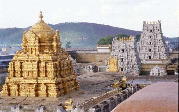
Tirupathy and Srirangam Gopuram Gold Layer by Shivappa Nayaka
Tirupathy and Srirangam Gopuram Gold Layer by Shivappa Nayaka ÜsÁT|ŸÜ`lsÁ+>·+ýË“ $eÖq >Ã|ŸÚs\Å£” ‹+>±sÁT |ŸPÔá |ŸPsTT+ºq ¥e|ŸÎ H...
-
 *********************************** provide invaluable information in deducing the prehistory of Telugu are closely related tribes. have a...
